This summer was the warmest on record in Brainerd; 2nd-hottest in Duluth
Temperatures have turned more seasonable to start September
Summer statistics are in, and many parts of the state had one of their hottest summers on record. September is starting much differently, with cooler weather on the way.
Hot summer statistics
While summer doesn’t officially end for another three weeks (the autumnal equinox is Sept. 22), meteorological summer is June, July and August, so it ended Monday.
Meteorological seasons are based on calendar months which is easier to track, versus the astrological seasons, which can vary in length from year to year.
Many parts of Minnesota had their top 10 hottest summers on record, although the Twin Cities fell just shy of that, tying for 11th-hottest. But for the Fargo-Moorhead area it was the fifth-hottest, Duluth had their second-hottest summer and Brainerd saw their hottest summer ever recorded:
Create a More Connected Minnesota
MPR News is your trusted resource for the news you need. With your support, MPR News brings accessible, courageous journalism and authentic conversation to everyone - free of paywalls and barriers. Your gift makes a difference.

Tuesday’s forecast
Tuesday started off with most of the state slightly below average and lows ranging from 30s in parts of the Arrowhead to 50s in central and southern Minnesota. High will be very seasonable for the start of September, with 70s across most of the state, and a few 80s possible in the southwestern corner of Minnesota.

Dry weather and partly cloudy skies prevail for most of the state, with a couple minor exceptions. A system well south of Minnesota is pushing a few light showers across the southern border Tuesday morning. Then in the afternoon and evening, a disturbance clips across northern Minnesota bringing a few showers and possibly isolated storms.
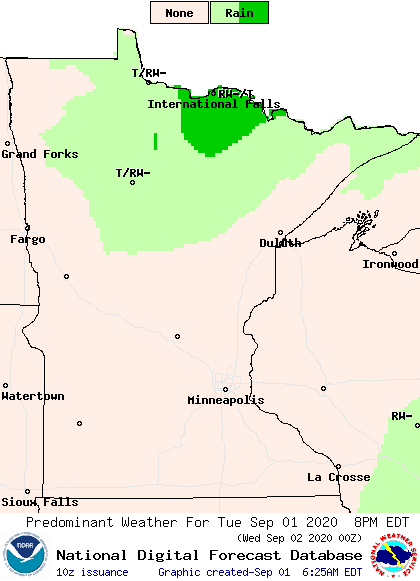
None of the weather is expected to be severe, and any precipitation would remain light.
Rain chances stay limited
Northern Minnesota sees another chance for nonsevere showers and storms late Wednesday and into the overnight thanks to a cold front sweeping across the state.
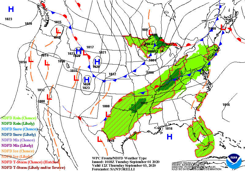
Although moisture with that system stays limited, it does bring statewide windy conditions on Thursday, with gusts over 20 and 30 mph.

After that, the next widespread rain possibility comes Sunday into Monday, but that may also have limited moisture with it.
Seasonable temperatures
Ahead of the cold front, southern Minnesota makes it into the 80s Wednesday. Then highs across the state drop into the 60s and 70s again Thursday behind the front. The weather starts warming again as we finish out the week. Here is that forecast for the Twin Cities:
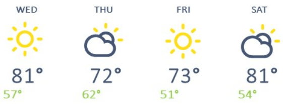
The extended forecast shows cooler temperatures ahead next week, including highs that may only be in the 50s north and 60s south by the middle of the week. Have the sweaters handy!
Programming note
You can hear my live weather updates on Minnesota Public Radio at 7:48 a.m. Monday through Friday morning.