Alisal Fire Is Now 97% Contained, In More than 17K Acres Burned And 12 Homes Were Destroyed
By
LAist Staff
Updated Jul 26, 2022 11:20 AM
Published Oct 12, 2021 11:05 AM
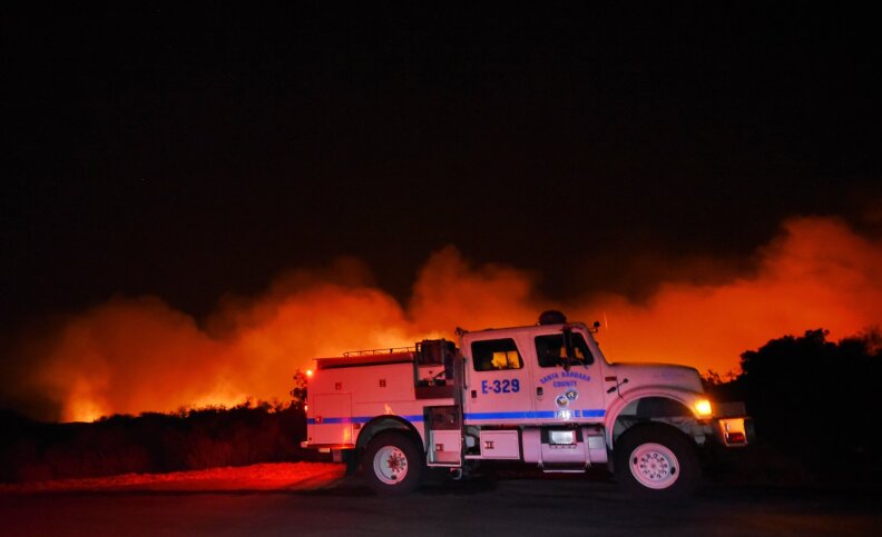
A Sikorsky S-64 Skycrane helicopter douses a hot spot near W. Camino Cielo.
(
Courtesy Santa Barbara County Fire Dept.
)
Support your source for local news!
In these challenging times, the need for reliable local reporting has never been greater. Put a value on the impact of our year-round coverage. Help us continue to highlight LA stories, hold the powerful accountable, and amplify community voices. Your support keeps our reporting free for all to use. Stand with us today.
The Alisal Fire had burned more than 17,000 acres and was 97% contained as of Tuesday night.
Officials announced Monday that all evacuation orders and warnings have been lifted.
The fire, the first major wildfire of the season in Southern California, has burned in coastal Santa Barbara County since it started on the afternoon of Oct. 11.
Firefighters made considerable progress in recent days but still report that "the main constraint has been heavy winds that have limited safe access to suppress the fire and limited the use of aircraft to engage and support fire suppression."
Chewing through dense chaparral, the fire has been fanned by heavy winds, with some gusts reaching 70 mph.
The blaze also whipped near Rancho del Cielo, a 688-acre property once owned by Ronald and Nancy Reagan. The property's manager, Flemming Bertelsen, said the flames came pretty close to the place that served as the former president's "Western White House."
View from the Reagan Ranch this week.
(
Courtesy Los Padres National Forest
)
Evacuation orders were issued shortly after the fire broke out. The blaze also shut down Highway 101, the only major road in the area, in both directions for several days. The railway parallel to the 101 was also closed, affecting Amtrak service.
Both the road and rail lines reopened Thursday after CalTrans crews repaired damage.
On Tuesday, officials reported:
"Minimal activity today, with cooler weather and moderate humidity after passing cold front. Areas near ridge top continues to have smoldering and creeping fire in and around unburned patches or islands of fuels."
The Basics
Acreage: 17,281
Containment: 97%
Structures destroyed: 12 residences
Structures damaged: 1 residence, 1 other structure
Resources deployed: 492 (as of Oct. 19)
Officials estimate it will be contained by midnight on Monday, Oct. 25.
#AlisalFire burn areas—like this one here north of #Goleta—undergo analysis by @forestservice BAER and @CAL_FIRE WERT scientists, who identify hazards and make recommendations to mitigate and prepare for any future flooding, post-fire debris flows and landslides. pic.twitter.com/jNzDZDti3b
As of 8:30 a.m. Monday, all evacuation orders and warnings have been lifted, though some areas are currently restricted to residents only: West of Arroyo Hondo to intersection of Highway 101 and Highway 1, the Arroyo Hondo Canyon and Refugio Canyon, and the area between El Capitan Beach State Park and West Camino Cielo.
Evacuation Centers
For people:
Dos Pueblos High School upper parking lot at 7266 Alameda Ave, Goleta, CA 93117.
For animals:
Earl Warren Showgrounds, for large animals. For animal evacuation assistance, call 805-681-4332.
County Animal Services (5473 Overpass Road, Goleta) is accepting small animals.
For animal evacuation assistance, call 805-681-4332.
Road And Train Closures
Highway 101 has reopened in both directions from Goleta to Highway 1, according to CHP.
The railway parallel to Highway 101 has also reopened for travel in both directions and all services are expected to back to normal. Weather Conditions
Weather
Forest officials reported of conditions on Tuesday:
At this time, there is high confidence in measurable rain late Sunday and Monday for the area with moderate confidence in significant precipitation developing.
Air Quality
Smoke from the Alisal Fire near Santa Barbara county initially pushed heavy smoke through Southern California. Earlier this week, the South Coast Air Quality Management District issued a smoke advisory.
By Saturday that was downgraded to a watch.
Remember, to help keep your indoor air clean you should keep windows and doors closed and run your AC, along with an air purifier.
And avoid any whole house fans or swamp coolers that bring outside air indoors.
The Background
The fire began on Monday afternoon, Oct. 11. It's unclear what started the blaze. Due to extremely gusty winds, flames moved unusually fast and the fire reached 8,000 acres at 0% containment by Tuesday afternoon.
"This area has not burned in over 60 years, which is remarkable," said Amalie Orme, professor of geography and environmental studies at Cal State Northridge.
Authorities also noted that the area burning is surrounded by major burn scars left behind by the Thomas Fire and other recent fires.
Scenes On The Ground
Twitter was filled with photos of massive plumes of smoke, visible from miles away.
The view from above the #AlisalFire this morning near Refugio Road. The fire is approximately 6,000 acres & there are 600 firefighting personnel working to contain the blaze. pic.twitter.com/4ZmO4RpbJW
#RT@CAL_FIRE: RT @EliasonMike: #Alisal Fire - UPDATE - 7 A.M. briefing. Gusty winds continued overnight, pushing the fire up to 6,000 acres, with 0% containment. There still are 100-120 structures threatened. Hopefully, lesser winds will allow air suppo… pic.twitter.com/wJeYU2f9dY
Fires are a critical part of the landscape in the Western U.S., but according to the Fourth National Climate Assessment, “the area burned by wildfire from 1984 to 2015 was twice what would have burned had climate change not occurred.” Put simply, hotter, drier conditions present throughout more of the year have made fuels more susceptible to burning across the state.
As Jacob Margolis, who covers science for us, reports in our LA Explained stories on the climate emergency and wildfires:
All but three of California’s 20 largest wildfires on record have occurred since the year 2000, with five of the top seven occurring in 2020 alone. And it’s anticipated that large fires will continue to be a problem.
Temperatures have gotten hotter and our landscapes have gotten drier, which makes them more susceptible to burning throughout more of the year. On top of that, extreme drought, of which climate change is a contributing factor, leads to plant stress and massive tree die off. Those dead trees become added fuel for fires.
How We're Reporting On This
This is a developing story. We fact check everything and rely only on information from credible sources (think fire, police, government officials and reporters on the ground). Sometimes, however, we make mistakes and/or initial reports turn out to be wrong. In all cases, we strive to bring you the most accurate information in real time and will update this story as new information becomes available.
Ryan Fonseca, Elina Shatkin, Jessica Ogilvie and other reporters and editors are keeping this story updated. Our daily news team, including Tiffany Ujiiye, Karina Gacad, Megan Nguyen and Megan Larson, are contributing to this report.
Additional Information
For the latest information straight from local emergency officials, check the following websites and social media accounts: